 By Nikolaos Ioannis Bountos, AI Researcher, Institute for Astronomy Astrophysics Space Applications & Remote Sensing, National Observatory of Athens
Pluto: A volcanic unrest early warning system bridging artificial intelligence and interferometry
Artificial intelligence (AI) methods have emerged as a powerful tool to study and in some cases forecast natural disasters [1,2]. The abundance of freely available satellite data (e.g from the Sentinel missions of the European Space Agency) puts us in an optimal position to investigate AI methods that can identify early signs of volcanic activity rapidly, enabling the creation of an efficient global early warning system. This research line is of utmost importance. According to [3] there are at least 29 million people that live within 10km from an active volcano. Unlike famous volcanoes like Etna and Stromboli, approximately 45% of the known subaerial volcanoes (~1500) have little to no monitoring systems. This is to be expected as the number of active volcanoes is disproportionate to the number of available observatories.
How can satellite data help us detect processes that happen deep underground?
To answer this, we have to first talk about Synthetic Aperture Radar Interferometry (InSAR). The Sentinel-1 mission has made Synthetic Aperture Radar (SAR) data readily available and abundant, providing new data every six days for every point on Earth (assuming all satellites are up and running). SAR provide us with two pieces of information. The first contains the amplitude of the signal, i.e. the strength of the signal’s response, while the second provides information on the signal’s phase. Under normal circumstances, one would need to focus on the amplitude of the signal, which provides a radar image of the earth’s surface. An example showing the island of Corfu can be seen below:

Identifying ground deformation on InSAR data
Rather than relying on the amplitude, we opt to exploit the phase information. The phase of the signal is mainly dependent on the distance between the satellite and the ground. Assuming two SAR captions of the same location, we can investigate their phase difference to extract a ground deformation map. This map illustrates the extent of the ground’s upward or downward movement between the two acquisitions. In the presence of volcanic activity, magma flowing in the magma chambers of the volcano causes the ground to uplift by a few centimeters. This deformation can be detected by experts by studying the respective InSAR. Early detecting of such activity can provide warnings months ahead of an eruptive event. The following figures illustrate examples of InSAR with and without ground deformation caused by volcanic activity.
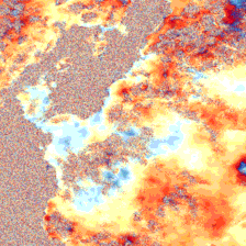
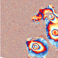
On the left hand side, we see a smooth image with slow color transitions. On the right hand side though, there are clear fringes that indicate volcanic activity. By studying these fringes, we can derive the intensity of the event as well as the state of the activity e.g unrest (magma is accumulating in the magma chamber) or rebound (the volcano is transitioning to a resting phase). Of course, both of these examples, constitute ideal samples for both ground deformation and normality. In real life however, we would need an expert eye to discern the patterns that indicate volcanic activity and other factors that could result in similar artifacts. Having experts carefully examine InSAR data for the whole globe is not feasible. To this end, we design a framework to “teach” a model to identify instances of volcanic activity and its characteristics (intensity, phase of the event etc.)
Teaching models to detect early signs of volcanic activity
![]()
A milestone in our quest has been the release of the Hephaestus [4] InSAR dataset, facilitating automatic InSAR interpretation, volcanic activity localization as well as the detection and categorization of atmospheric contributions in wrapped interferograms. Hephaestus contains annotations for approximately 20,000 InSAR frames, covering the 44 most active volcanoes in the world. The annotation was performed by a team of InSAR experts that manually examined each InSAR frame individually. This dataset enables us to train deep learning models on the task of volcanic activity detection.
Below we present a few samples from Hephaestus, along with their deformation type and the respective mask, highlighting the area that indicates volcanic activity.

Challenges on the intersection of AI and natural hazards
Despite having a vast dataset, class imbalance remains a significant challenge. The InSAR samples containing volcano deformation fringes are orders of magnitude less than those that do not. This is anticipated since natural hazards are in principle rare in nature. This scarcity of data make the training of supervised models particularly challenging. To make things worse, factors like atmospheric contributions and processing errors can produce fringes similar to those caused by volcanic activity.
To counter that, we collect ~1,000,000 (~1TB) unlabeled InSAR frames to be used for global large-scale self-supervised learning (SSL). SSL is more robust to class imbalance when compared to supervised learning [5] and enables the exploitation of the massive amount of available data without the need for human supervision.
In a self-supervised learning (SSL) setting, we learn from unlabeled InSAR by exploiting the intrinsic characteristics of the data. This approach results in a task-agnostic model that learns features capable of generalizing well to different conditions and tasks, making it more robust to spatio-temporal variability and class imbalance.
Making such models publicly available, will be groundbreaking for various InSAR applications, regardless of their relevance to volcanic unrest detection. Our previous research [2], has validated the advantages of SSL for the InSAR domain even in lower data regimes.
By finetuning our task-agnostic model to the labeled part of Hephaestus we obtain the backbone for our global volcanic activity alerting system, namely Pluto.
Pluto: Global volcanic activiting early warning system
Pluto is a novel end-to-end AI based system that provides early warnings of volcanic unrest on a global scale.
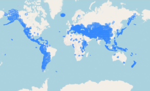
Pluto synchronizes its database automatically with the Comet-LiCS [6] portal to receive newly generated Sentinel-1 InSAR data acquired over volcanic areas worldwide. Wide coverage is essential as there are many unmonitored volcanoes posing a significant threat to nearby populated areas. In such cases, early warnings can be a critical in minimizing possible fatalities. Pluto’s spatial coverage can be seen below.
Our volcanic activity detection model processes the newly acquired InSAR data. If volcanic activity is detected, an automatic email is sent to the service users with information on the inferred intensity, precise location and the type (Mogi, Sill, Dyke) of the event.


To ensure a robust and ever-improving service, we implement an iterative pipeline within Pluto that collects misclassified samples from production and employs them to improve the existing model. To acquire such samples, a trustworthy evaluation scheme is crucial. Hence, we include InSAR experts in our network, that regularly validate the predictions of our system and provide feedback.
The full pipeline is described in the following figure.

Next steps
Currently, Pluto is undergoing evaluation and fine-tuning. Over the next months, our team will prioritize improving the volcanic unrest detection model, while also creating a publicly available task-agnostic model zoo to advance research on InSAR related tasks.

References
[1] Kondylatos et al. “Wildfire danger prediction and understanding with Deep Learning.” Geophysical Research Letters 49.17 (2022): e2022GL099368.
[2] Bountos et al. “Self-supervised contrastive learning for volcanic unrest detection.” IEEE Geoscience and Remote Sensing Letters 19 (2021): 1-5.
[3] S. K. Brown, S. F. Jenkins, R. S. J. Sparks, H. Odbert, and M. R. Auker, “Volcanic fatalities database: analysis of volcanic threat with distance and victim classification,” Journal of Applied Volcanology, vol. 6, no. 1, pp. 1–20, 2017.
[4] Bountos et al. “Hephaestus: A large scale multitask dataset towards InSAR understanding.” Proceedings of the IEEE/CVF CVPR. 2022.
[5] Liu et al. “Self-supervised learning is more robust to dataset imbalance.” arXiv preprint arXiv:2110.05025 (2021).
[6] Lazecký et al. “LiCSAR: An automatic InSAR tool for measuring and monitoring tectonic and volcanic activity.” Remote Sensing 12.15 (2020): 2430.