Fire hazard forecasting in the Mediterranean


This Use Case aims to increase the operational preparedness of civil protection authorities and fire brigades with fire hazard forecasting systems using AI on big EO and non-EO data. DeepCube examines – among others – the climatic and vegetation status and the anthropogenic drivers that impact fire proneness, based on multivariate historical data analysis, burned area trends in Mediterranean ecosystems, the modeling of fire hazard to make more accurate future predictions using EO data time-series analysis, and the impact of vegetation recovery dynamics on inter-seasonal fire risk. We apply hybrid modelling, coupling physical models with data-driven Machine Learning, to create robust fire hazard forecasts at large scales and enhance our understanding of fire dynamics in complex ecosystems.
This use case has been co-designed with the support and contribution of the Hellenic Fire Service (HFS).
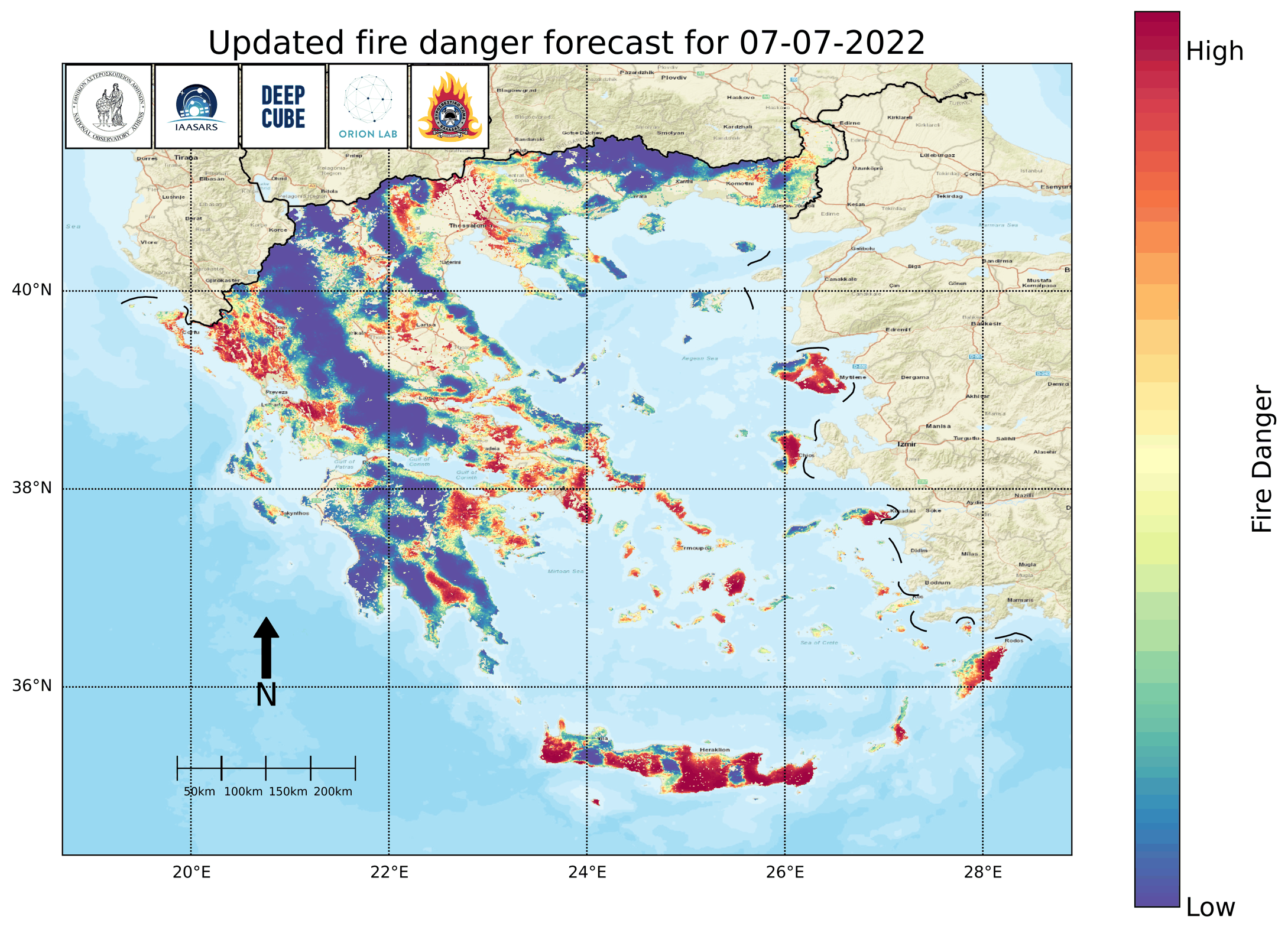
We have developed a pre-operational service that daily provides next-day fire danger forecasts to the HFS, with better accuracy than existing solutions and at 1km x 1km spatial resolution.
We have expanded the service with explainability plots as an additional product, which gives the opportunity to the user to see for a pixel of interest the main drivers behind the model’s prediction. The final system will also provide to the user risk assessment based on asset exposure, which will show the fire risk for the high fire danger territories in the Area of Interest based on queries pre-defined by the HFS.
Datacube for the analysis of wildfires in Greece
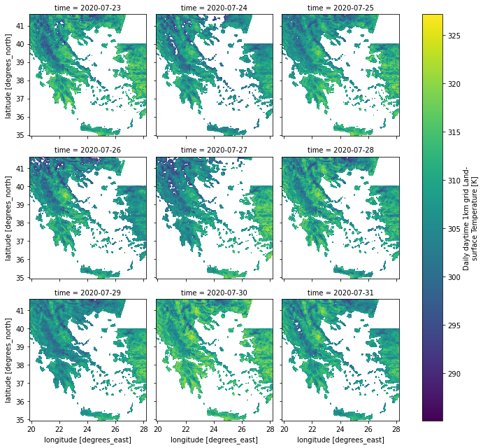
This dataset is meant to be used by the wildfire research community to develop models for next-day fire hazard forecasting in Greece. It contains data from 2009 to 2020 at a 1km x 1km x 1 daily grid. To download the data cube please visit http://doi.org/10.5281/zenodo.4943354
The dataset includes dynamic variables, such as previous day Leaf Area Index, evapotransiration, Land Surface Temperature, meteorological data, fire variables and Fire Weather Index, resampled at daily temporal resolution and 1km spatial resolution. It also includes static variables, such as roads density, population density and topography layers.
mesogeos: A Daily Datacube for the Modeling and Analysis of Wildfires in the Mediterranean
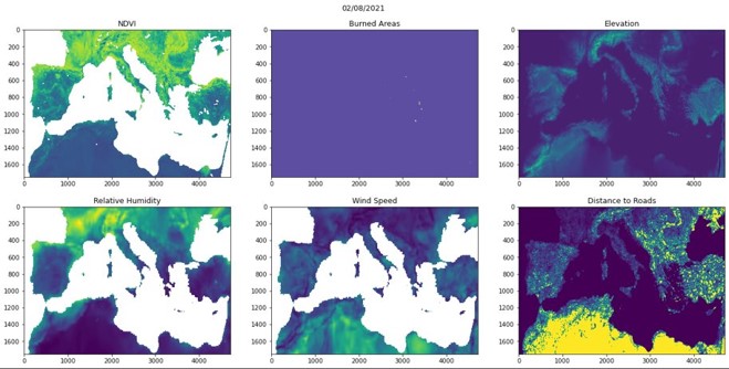
mesogeos is meant to be used to develop models for next-day fire hazard forecasting in the Mediterranean. It contains variables related to the ignition and spread of wildfire for the years 2002 to 2022 at a daily 1km x 1km grid.
Available at https://doi.org/10.5281/zenodo.7473332
More information and link for downloading the dataset can be found in https://github.com/Orion-AI-Lab/mesogeos
The dataset contains satellite data from MODIS, weather variables from ERA5-Land, soil moisture index from JRC European Drought Observatory, population count & distance to roads from worldpop.org, land cover from Copernicus Climate Change Service, elevation, aspect, slope and curvature from Copernicus EU-DEM, and burned areas and ignition points from EFFIS.
For more information about DeepCube’s published datasets, please visit https://deepcube-h2020.eu/datasets/
Publications
I. Prapas, S. Kondylatos, I. Papoutsis, G. Camps-Valls, M. Ronco, M. Fernández-Torres, M. Piles, N. Carvalhais, Deep Learning Methods for Daily Wildfire Danger Forecasting, Workshop on Artificial Intelligence for Humanitarian Assistance and Disaster Response at the 35th Conference on Neural Information Processing Systems (NeurIPS 2021), https://doi.org/10.48550/arXiv.2111.02736
Ronco, M., Prapas, I., Kondylatos, S., Papoutsis, I., Camps-Valls, G., Fernández-Torres, M.-Á., Piles Guillem, M., and Carvalhais, N.: Explainable deep learning for wildfire danger estimation, EGU General Assembly 2022, Vienna, Austria, 23–27 May 2022, EGU22-11787, https://doi.org/10.5194/egusphere-egu22-11787, 2022
S. Kondylatos, I. Prapas, M. Ronco, I. Papoutsis, G. Camps-Valls, M. Piles, M. Fernández-Torres, N. Carvalhais, Wildfire Danger Prediction and Understanding With Deep Learning, AGU Geophysical Research Letters, https://doi.org/10.1029/2022GL099368
Spyros Kondylatos, Ioannis Prapas, Gustau Camps-Valls, Ioannis Papoutsis, Mesogeos: A multi-purpose dataset for data-driven wildfire modeling in the Mediterranean, Accepted at the 37th Conference on Neural Information Processing Systems (NeurIPS 2023) Track on Datasets and Benchmarks (oral presentation), https://doi.org/10.48550/arXiv.2306.05144
Use Case Leader
National Observatory of Athens
Interested in learning more? Contact us!
Dr. Ioannis Papoutsis, [email protected]