


By Christian Requena-Mesa, Claire Robin, Vitus Benson, Lazaro Alonso, Nuno Carvalhais, Department Biogeochemical Integration, Max Planck Institute for Biogeochemistry
Climate change is reshaping our planet, leading to more frequent and severe extreme weather events that pose significant challenges to ecosystems and human livelihoods. Among the continents most vulnerable to these climate shifts, Africa stands at the forefront, with the Intergovernmental Panel on Climate Change (IPCC) projecting an increase in drought severity across the region. As population growth continues alongside the impacts of climate change, an ever-increasing number of people will be exposed to the devastating consequences of extreme drought events. In light of this alarming reality, gaining insights into the prediction and occurrence of these events becomes crucial for preparing short-term solutions to alleviate potential impacts on local and regional communities.
The challenges
The response of vegetation to extreme weather events is not uniform across local scales. Various abiotic factors such as soil type, topography, and water bodies, as well as biotic factors like vegetation type and plant rooting depth, together with their intricate interactions, influence how vegetation responds to atmospheric extremes. Furthermore, the temporal lagged responses between weather impacts and ecosystem dynamics have a profound impact on vegetation’s ability to withstand and recover from weather variability. These time-lagged effects, often referred to as the “memory effect,” stem from the intricate ecological processes that govern vegetation dynamics, resulting in non-linear interactions across multiple time scales.
In this context, accurately predicting and understanding the evolution and impacts of vegetation at a local level becomes a critical challenge. By doing so, we can support anticipatory actions and proactive measures before disasters strike. In the context of DeepCube and under the EarthNet initiative, we work on developing groundbreaking models that can learn the intricate relationship between vegetation states, local factors, and weather conditions at an exceptionally fine resolution. Our models aim to characterize and forecast the impact of weather from an ecosystem perspective, focusing on the African continent.
How does it work?
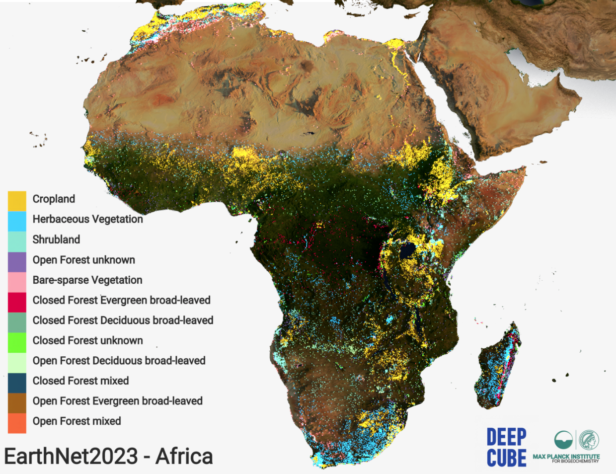
The foundation of our work lies in the use of the Normalized Difference Vegetation Index (NDVI) as a proxy for monitoring vegetation health. NDVI captures the greenness and vitality of vegetation, making it a powerful indicator for assessing ecosystem dynamics. In addition, NDVI can be measured from space at high resolution. By leveraging this index and integrating it with high-resolution satellite data, weather reanalysis from the ERA5 dataset, topography data and several other sources, we construct a comprehensive dataset that enables us to train models that perform accurate predictions. We named the dataset EarthNet 2023.
To tackle the complex challenge of forecasting vegetation greenness, we have tested many of the state-of-the-art-deep learning models. The best performing model employs a Convolutional LSTM (ConvLSTM) architecture. This model that was initially used for video prediction tasks combines convolutional layers, which excel at capturing spatial patterns, with LSTM layers, which effectively capture temporal dependencies. By integrating these two components, our model can learn the intricate spatio-temporal characteristics of vegetation development and make accurate predictions of vegetation state changes over time.
More about the models
In more detail, the ConvLSTM model, comprising encoder and decoder units, was trained using a context period of one year and then used to forecast the next three months of NDVI at a 10-daily time step. The evaluation metrics provided insights into the model’s accuracy and efficiency in forecasting vegetation greenness.
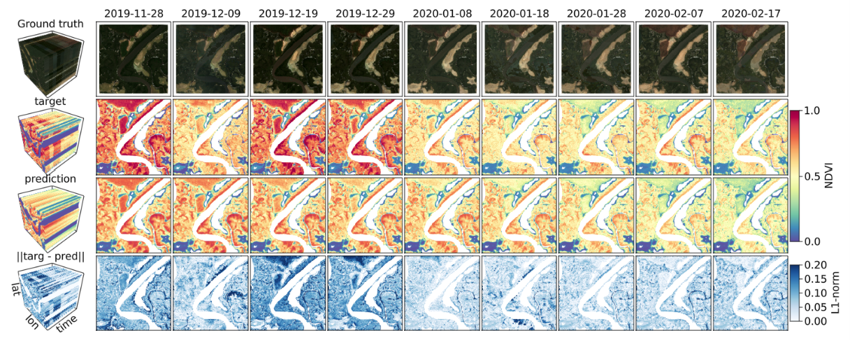
The inclusion of weather covariates significantly improved the model’s performance, highlighting the importance of meteorological information in vegetation dynamics. The model was trained on a diverse dataset, making it applicable to various land cover classes and climate zones. However, the model showed vulnerability to data noise caused by undetected clouds. Nevertheless, this work serves as a proof-of-concept for high-resolution vegetation modeling in Africa, and future research should focus on improving predictions by considering spatial context, addressing extreme events, and bridging the gap with anticipatory action initiatives.
Summarizing, our experiments focus on the African region, encompassing diverse vegetation types and considering the varying NDVI variability within them. This approach allows us to assess the model’s ability not only to forecast the seasonal evolution of NDVI at high resolution but also to capture the differential impacts of weather anomalies compared to baselines. Through our spatio-temporal analysis, we gain valuable insights into the performance and capabilities of our ConvLSTM model, offering promising prospects for supporting anticipatory actions in the face of drought-related disasters.
What next?
The potential applications of our work extend beyond vegetation forecasting. Anticipatory actions, such as Forecast-based Financing (FbF), rely on short-term interventions before disasters occur to mitigate their impact and reduce the financial burden of humanitarian aid. However, the uncertainty surrounding the occurrence, magnitude, and precise location of disasters often hinders timely decision-making and response strategies. By providing a localized vegetation evolution tool that predicts drought vulnerability at a very fine resolution, our model can support anticipatory actions by offering insights into the location and magnitude of potential drought impacts. Furthermore, as our model relies solely on satellite data, it is particularly relevant for regions lacking in situ meteorological and vegetation monitoring instruments, which is notably the case in Africa.
In conclusion
Our work represents a significant advancement in vegetation greenness forecasting, harnessing the power of advanced machine learning techniques and a comprehensive dataset. By accurately predicting vegetation dynamics at a local scale, we aim to equip decision-makers, policymakers, and humanitarian organizations with valuable information to guide proactive measures and reduce the impact of drought-related disasters. The Earthnet initiative paves the way for a more resilient and sustainable future, where anticipatory actions can be taken to protect ecosystems and the well-being of communities across Africa.
Sources
EarthNet: https://www.earthnet.tech/
Claire Robin, Christian Requena-Mesa, Vitus Benson, Lazaro Alonso, Jeran Poehls, Nuno Carvalhais, and Markus Reichstein, Learning to forecast vegetation greenness at fine resolution over Africa with ConvLSTMs, 2022, https://arxiv.org/pdf/2210.13648.pdf
EarthNet minicuber: https://github.com/earthnet2021/earthnet-minicuber
EarthNet models pytorch: https://github.com/earthnet2021/earthnet-models-pytorch
EarthNet 2023 dataset: https://www.earthnet.tech/en23/ds-africa/